GEOTECHNICAL ENGINEERING
QUEBEC CITY
HomeGeophysicsElectrical resistivity / VES (Vertical Electrical Sounding)

Electrical Resistivity & VES (Vertical Electrical Sounding) for Quebec City Sites

Evidence-based design. Reliable delivery.

LEARN MORE

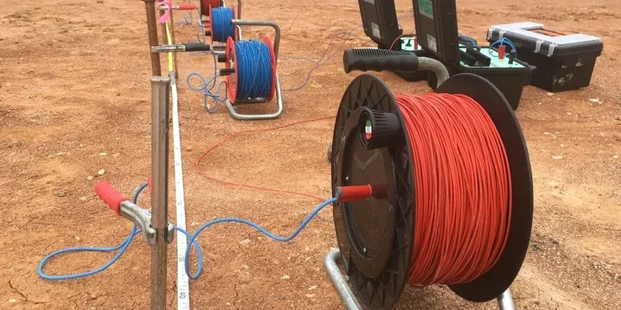
With a population hovering around 550,000 and a metropolitan area that climbs the cliffs of Cap-Diamant, Quebec City presents a fascinating geophysical challenge. The promontory itself, rising over 90 meters above the St. Lawrence, is underlain by Ordovician sedimentary rock, but the lower town and Saint-Roch areas sit on thick sequences of post-glacial marine clays and deltaic sands. These abrupt transitions—from bedrock to compressible Champlain Sea deposits—mean that a standard geotechnical borehole can only tell part of the story. We run vertical electrical soundings (VES) to map these contrasts across a site in a matter of hours, giving project owners a continuous profile of subsurface resistivity before they commit to excavation or foundation design. It is a tool we have applied on everything from university expansions to port-side infrastructure in the Old Capital, and it consistently reveals hidden lenses of soft clay that would otherwise complicate a build.

A well-executed VES survey in the Quebec City region can pinpoint the depth to bedrock within 10% accuracy, cutting through the ambiguity of Champlain Sea sediments.

Our service areas

Our approach and scope

The field setup we deploy in Quebec City starts with a solid multi-electrode array—typically a Schlumberger configuration for VES work, though we switch to dipole-dipole when lateral resolution is critical near the fault-controlled escarpment. The transmitter injects a controlled DC current into the ground, and the potential electrodes measure the resulting voltage drop; the ratio gives us apparent resistivity at progressively deeper levels as we expand the electrode spacing. In the limestone and shale bedrock of the Upper Town, resistivity values often exceed 500 ohm-m, while the saturated silty clays of the Saint-Charles River lowlands drop below 15 ohm-m. This contrast is what makes electrical resistivity such a powerful reconnaissance tool. We pair the raw field data with inversion software to generate 2D and 3D resistivity models, and when the project demands it—say, for a deep excavation near a heritage building—we complement the geophysics with a targeted grain size analysis on soil samples extracted from the most critical horizons to calibrate the resistivity-to-lithology interpretation.
Electrical Resistivity & VES (Vertical Electrical Sounding) for Quebec City Sites
Technical reference — Quebec City

Site-specific factors

Quebec City’s urban fabric expanded rapidly from the 1960s onward into the northern suburbs, much of it built over a thick blanket of sensitive Champlain Sea clay that was poorly mapped in early development decades. The risk of differential settlement and quick-clay landslides—documented catastrophically in Saint-Jean-Vianney in 1971—remains a design consideration for any engineer working in the region today. Ignoring the lateral variability of these deposits is not an option when a resistivity survey can trace the boundaries between competent till, soft clay, and bedrock in a single afternoon. We have seen projects where a resistivity low, initially dismissed as a wet patch, later turned out to be a buried paleochannel filled with organic silt; catching that early meant the difference between a standard footing design and an expensive ground improvement program. For any project near the river or the Laurentian bedrock transition, the VES data becomes part of the risk register from day one.

Need a geotechnical assessment?

Reply within 24h.

Email: info@geotechnical-engineering.org

Applicable standards

NBCC 2015 (National Building Code of Canada), ASTM D6431-18 (Standard Guide for Using the Direct Current Resistivity Method), CSA A23.3 (Design of Concrete Structures, referenced for foundation design integration), Canadian Geotechnical Society – Canadian Foundation Engineering Manual

Reference parameters

ParameterTypical value
MethodSchlumberger, Wenner, Dipole-Dipole arrays
Max Investigation DepthUp to 120 m with AB/2 = 200 m
Typical Bedrock Resistivity (Limestone/Shale)200 – 800 ohm-m
Typical Clay Resistivity (Champlain Sea)5 – 25 ohm-m
Data Acquisition SystemMulti-electrode, 48–72 channels
Reporting Standard2D/3D inversion models, ASTM D6431
Survey Duration (Standard VES)1–3 hours per sounding
Applicable NormsNBCC 2015, ASTM D6431-18

Quick answers

What does a VES survey typically cost for a residential lot in Quebec City?

For a single-family residential lot within the Quebec City region, a standard vertical electrical sounding with four to six depth levels typically runs between CA$850 and CA$1,580. The final figure depends on site access, the number of soundings required, and whether we are working on a steep slope in the Upper Town or a flat lot in Beauport.

How deep can the electrical resistivity method investigate in the St. Lawrence lowlands?

With a Schlumberger array and a maximum current electrode spacing (AB/2) of 200 meters, we can reliably reach depths of 100 to 120 meters in the Champlain Sea deposits. In practice, most construction-related surveys in Quebec City target the upper 30 to 50 meters to capture the bedrock interface and any major clay lenses.

Does winter weather affect the quality of a resistivity survey in Quebec City?

Frozen ground does increase contact resistance at the surface, but we adapt by using bentonite-enhanced electrodes and sometimes a warm-water pre-soak at each stake. The underlying soil and rock resistivity remain measurable, and we have run successful VES campaigns in February when the air temperature was -20 °C. Snow cover is not a limitation; ice lenses in the active layer are something we account for during data processing.

How does electrical resistivity complement traditional geotechnical drilling on a Quebec City project?

A borehole gives you a point measurement of soil stratigraphy; a VES gives you a continuous cross-section between boreholes. We use resistivity to interpolate the geology, identify zones where the clay is thicker or thinner than expected, and then place additional boreholes or CPT soundings exactly where the geophysics indicates a transition. It is a way to reduce the total number of invasive tests without sacrificing subsurface coverage.

Is the VES method suitable for detecting underground utilities before excavation?

Electrical resistivity can detect metallic utilities as strong conductive anomalies, but it is not a replacement for a dedicated private utility locate. We coordinate with utility locators and use our resistivity data to flag areas where additional ground-truthing is needed; the method is particularly useful for identifying abandoned buried tanks or old foundations in the Saint-Roch industrial district where records are incomplete.

Location and service area

We serve projects in Quebec City and surrounding areas. More info.

View larger map